A website by Edward (Ted) Relph exploring the concept of place, sense of place, spirit of place, placemaking, placelessness and non-place, and almost everything to do with place and places
This post summarises two considerations that are I think are essential for an attempt to forecast the future of places over the next thirty or more years, • Continuity, or the aspects of places that persist in spite of change • The triggers that have frequently played a role in causing changes in how places have been made
Continuity in Places The identities of places are the product of both continuity and of change. Some aspects of their identities tend to persist, enduring for centuries or even millennia. Other aspects, the ones that comprise much of the character of places, are the result of adaptation to and accommodation of changes.
Persistence: The names of particular locations, unless they are forcibly removed by conquest and colonisation, can stick for centuries, even millennia. The same can be said of roads and street patterns, Once created, these are unlikely to be changed in any substantial way, presumably because they are public rights-of-way that are needed for places to function. Some institutions – the Catholic and other Churches, universities – have found ways to survive repeated political and economic turmoil. And it is striking that the even though the hey-day of religious placemaking was in the Middle Age, not only have cathedrals built then survived to the present, but new ones, for instance in Liverpool and Barcelona, were still being built in the 20th century. The first universities were also a product of the Middle Ages, and university campuses have multiplied and are still expanding.
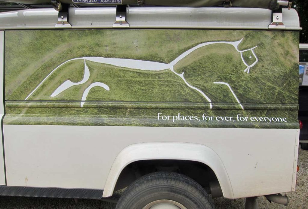
The White Horse, carved into the chalk hillside at Uffington in England, is a remarkable case of persistence of a place. This image from 2016 is an aerial depiction wrapped onto a National Trust vehicle in the parking lot at site of the White Horse in 2016. The original significance and purpose of the carving is unknown, but it was probably made about 3000 years ago and has had to be recarved about every seven years since then to prevent grass growing over it. The idea of continuity of place here is reinforced by the National Trust slogan “For places, for ever, for everyone.”
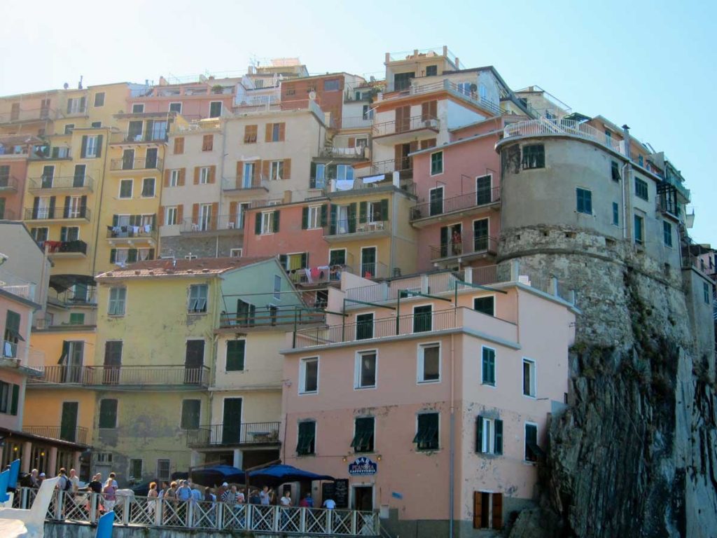
Another form of place persistence happens when towns or villages were by-passed by progress yet were sufficiently resilient to survive in spite of that. The result is landscapes and townscapes left mostly untouched by changes happening elsewhere, where local architectural styles and other placemaking practices continued to be used. (Now, of course, places like this are deliberately preserved for their picturesque heritage qualities and new buildings are required to be in complementary designs).
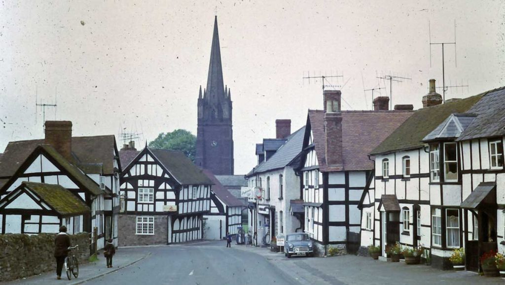
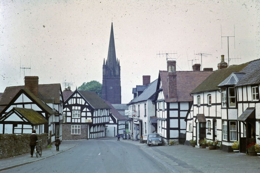
Vernazza in the Cinque Terre in Italy, and Weobley in Herefordshire, England. Two places demonstrating persistence of identity – each with a distinctive styles of vernacular architecture that has been used over several centuries. In Weobley the oldest black and white buildings in the middle distance date from the 15th century and those in the foreground from the 19th century.
Adaptive Continuity: The second form of continuity in places happens through the accommodation of shifts in ways of building or social and economic circumstances by adding to or modifying whatever already exists. The consequence is that, although there may have been a radical change in ways of making and experiencing places, the personality of a particular place has continuity because it has been altered incrementally around a core identity that involves names and older buildings. Elements from different eras are interspersed and juxtaposed, and the resulting townscape expresses what might be called adaptive continuity.
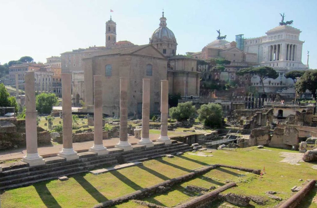
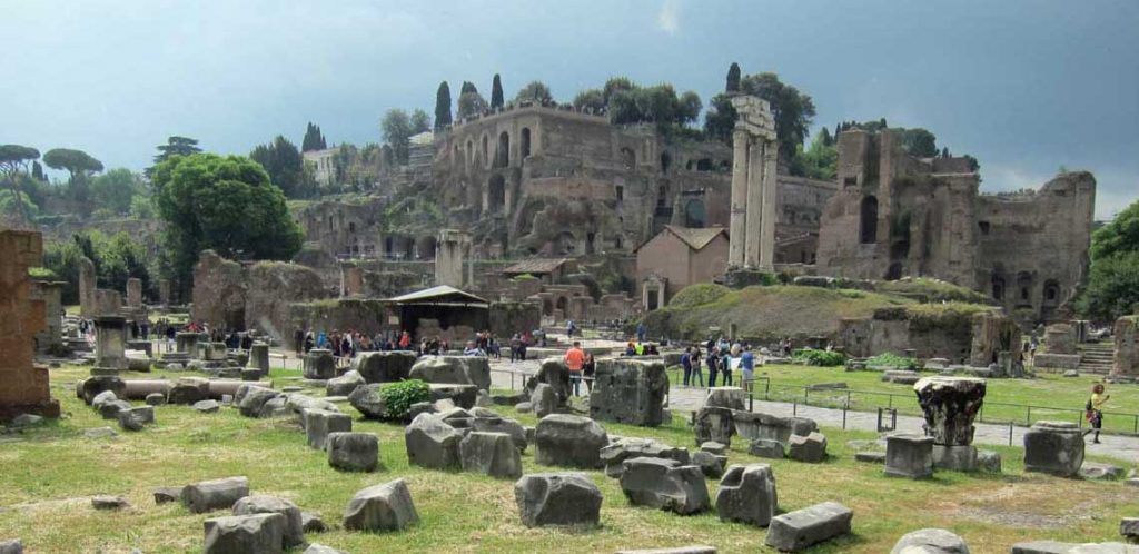
Adaptive continuity of place. The Forum in Rome with the Capitoline hill in the background. The Forum was in use for over 1000 years and has ruins from many centuries jumbled together because the Romans built over what already existed. On the Capitoline Hill the Basilica di Santa Maria (the dome) was founded in the 6th century; the tower is part of the Musei Copitolini which consists of buildings constructed between the 12th and 17th century, and was opened as probably the first museum in the world in the 18th century; it faces onto the Piazza del Campidoglio designed by Michelangelo in the 16th century; the building with angels is the Altare della Patria, built in 1880s and 1890s.
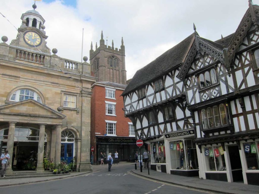
Adaptive continuity and change in Ludlow, an English town close to the Welsh border, founded in the 11th or 12th century by the Normans, loosely planned with a grid of streets (still in use), adjacent to a castle (not visible here). The church in the background was founded in the 12th century, the tower was built in the 15th century. The black and white building was constructed in 1404, and may have been in a use as a shop continuously since then. The stone building is the Buttercross, built 1743-1746 to be a meeting room. The brick building is a few decades newer than that and has a plaque on the side noting that in the 1980s an influential magazine about video games was published here. The red and white No Entry sign is a 20th century installation.
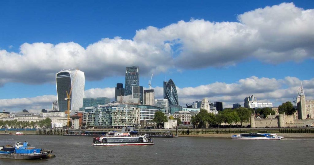
Adaptive continuity and persistence of place in the City of London in 2018. The site of pre-Roman settlement, the name derives from the Roman Londinium; the medieval Tower of London is on the right; there are various buildings from the 19th century, early 20th century, post-World War 2 rebuilding, and the strangest, tallest ones from the 21st century,
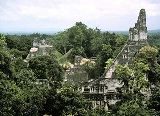
Of course, villages and small towns have sometimes been abandoned because they are economically obsolete, or effectively disappeared because they have been swallowed by urban development. Nevertheless, most large towns and cities that were founded more than about a century ago are likely to show evidence of adaptive continuity to meet changing circumstances. The overwhelming evidence is that place want to survive and that the largest ones also want to continue growing. For places on the scale of Uruk or Tikal to be abandoned in takes the collapse of entire civilization.
The Mayan city of Tikal in Guatemala was a major centre for a millennium. At its peak about 800 CE it may have had a population of 90,000 , but was abandoned in the 10th century as Mayan civilization collapsed, probably for a combination of political and environmental reasons.
Triggers for Change in Places As I have indicated in previous posts (here and here) the history of places also shows that, for all their continuity, there have been several fundamental changes in how places have been made and experienced over the last 2500 years. Each of these changes was the result of a radical shift that involved some combination of, I think, four major processes • technological innovations • new ways of thinking about the world and the role of humans in it • the emergence of political and social structures that allowed those new technologies and ways of thinking to be turned into practices • underlying all of these, population and urban growth drive the need for more and larger places.
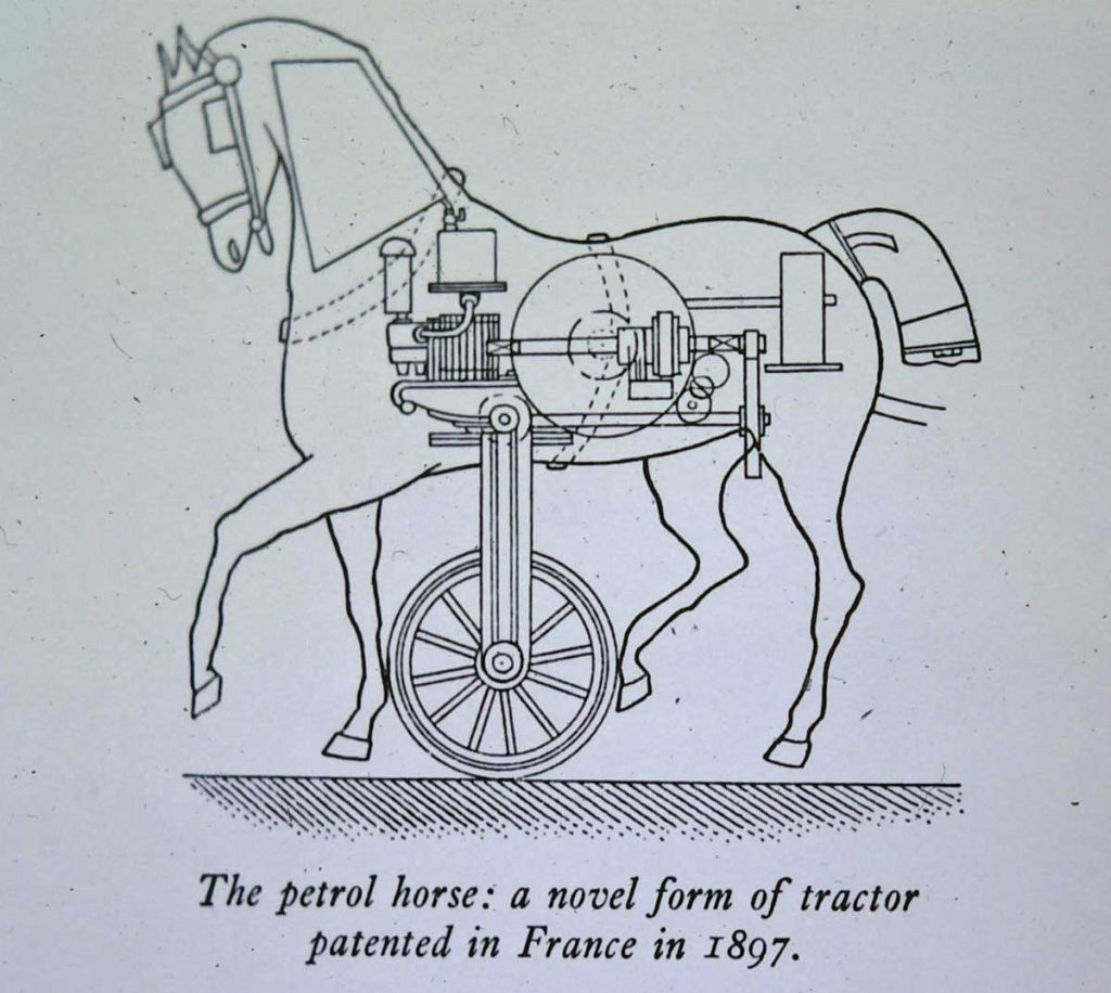
An 1897 patent application for a Petrol Horse/Tractor suggests how easy it is to see technological innovations only in terms of current practices
Technological Innovations: The invention of new technologies – especially media of communication (roads, printing, railways, telegraph and telephone, highways and motor vehicles) – modified relationships between places by speeding up how knowledge and practices were transferred between them. In addition, other innovations (columns, domes, pointed arches, domes, steam power, materials such as concrete and steel frames for skyscrapers) introduced new types of building that made possible new ways of making places. In hindsight, these technologically induced changes seem to be clear, but at the time their consequences can be far from obvious and are easily misinterpreted.
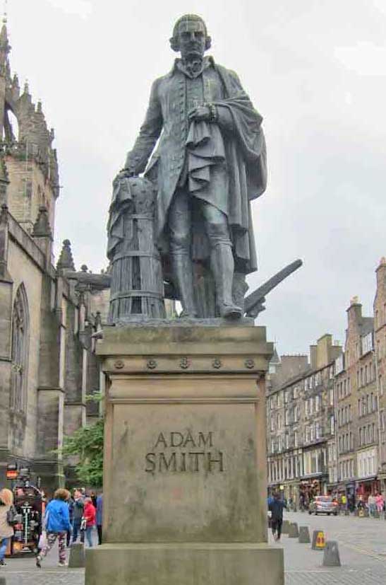
The statue of Adam Smith in Edinburgh
Ideas and Systems of Belief: The emergence of new world views or religious beliefs played a role in the emergence of every new period of places – Roman imperialism and pragmatism overwhelmed Classical Greece; Christianity provided an organisational foundation for societies to emerge from the Dark Ages; the Age of Reason drew inspiration from the Classical Period relegated religion to a secondary role and remade landscapes along geometric lines; the refinement of economic thought by Adam Smith was a foundation for the industrial capitalism in the Industrial Era that converted reason into utilitarianism for the benefit of profit; Modernism rejected historical revivals and turned capitalism towards efficiency and an international view of the future in which the distinctiveness of places was almost irrelevant.
Political and Social Values: Changes in belief systems were usually connected with shifts in political values and power. The Romans developed practices of government and administration that made possible the expansion of the Empire; failure of that system of government and the security it provided resulted in the disorder of the Dark Ages. The administration of the Catholic Church, which was the foundation for making places at the beginning of the Middle Ages, was weakened as popes and cardinals became increasingly absorbed with their own power and wealth. Authority passed to kings and princes, but in due course, they too became self-aggrandizing and detached from the people they ruled, and monarchies were overthrown in various revolutions that established versions of liberal democracies that have prevailed since the early 19th century. In general, it seems that whenever social and economic inequality has intensified it has contributed to enduring shifts in political systems, and that these have been associated with new ways of making and experiencing places.
The Forum in Rome (some places have many stories to tell) is a monument to the megalomania of Roman emperors, each one apparently building a larger, grander temple than their predecessors, often by dismantling and reusing parts of older ones. They all collapsed after the decline of the Empire.
Growth: Population and urban growth underlie the entire history of places (as I indicated here). It is, however, not clear in what ways these have been triggers for particular changes except as ongoing background demands that have had to be resolved by making more places, for instance by creating colonies or new towns, and by making existing places larger. In these respects the very rapid population and urban growth since 1800 has had a profound impact on how places have been made. This impact has been especially pronounced since about 1970 as global population doubled and cities almost everywhere have grew both upwards and outwards at unprecedented rates and scales.
Implications for the Future of Places The message of persistence and adaptive continuity for the future of places is clear. Notwithstanding some massive disaster, many aspects of places as they are now will continue to exist for decades and possibly centuries. Furthermore, because the world’s population has doubled from 1970 to 2020 (from 3.7 billion to 7.5 billion), and the majority of that growth has been accommodated in urban areas (from 1.4 billion to 4.3 billion), most of the current built environment and its places are products of the last half century. There will, of course, be modifications and adaptations to these as new technologies are developed, and new ideas and social systems emerge, but in some form the places made over the last half century will be a huge part of the places of the foreseeable future.
In order to contemplate the future of places, the almost certain fact of this continuity has to balanced against indications that the various triggers for change – technological innovations, systems of belief, social and political values – could be intensifying. In my next post I will examine trends hat have emerged in the last half century which are affecting ways that places are made and experienced, and are likely to continue to do so in the immediate future.
This post is the second part of a history of places and is one in a series about the past and future of places. An initial post explained my overall aims, and noted that my emphasis is on material places rather than the more abstract notion of place. The first part of the history of places considered how places changed from about 10,000 BCE to 1000 CE, noted my criteria for identifying historical periods of places, and identified some qualifications about my approach, including the fact that population and urban growth have always been in the background of how places have been made.
Note that the brief history in these two posts is only intended to provide sufficient information to give a broad indication of the different ways places have been made and experienced over the course of human history. Rather than primary research, it draws on secondary and web sources, combined with my direct experiences of the remnants of places from particular historical periods (which I illustrate where I can with my own photos).
This post considers places in four distinct periods – the Middle Ages, the Age of Reason, the Industrial Century, and the Modern Era.
Religion and the Places of the Middle Ages The Dark Ages between about 500 and 1,000 CE witnessed a disaggregation of places as towns and settlements that had been established throughout the Roman Empire declined or were abandoned in the absence of political coherence. From the 10th century some measure of stability began to be re-established as Christianity, which had developed as an organized religion in the last centuries of the Roman Empire and then slowly spread across Western Europe, was increasingly adopted by the rulers of regional kingdoms. With stability came the possibility of making places that might endure, and from the 11th to the 15th centuries Christianity dominated the character of how those places were made. Villages and towns were essentially built around churches or cathedrals, which were often magnificent structures with pointed arches, stained glass windows, ornate decorations, flying buttresses, and spires pointing heavenward. They were physical demonstrations of the narrative that religion and faith were the most important aspects of existence. Everyday life for everyone was permeated by religion, princes and peasants alike. It set the rhythms of the day, the week and the year; it was the foundation of education; nuns and monks ran hospitals and attended to the poor and destitute; everyone contributed in some way to the building of churches, if not with money then by providing their labour.
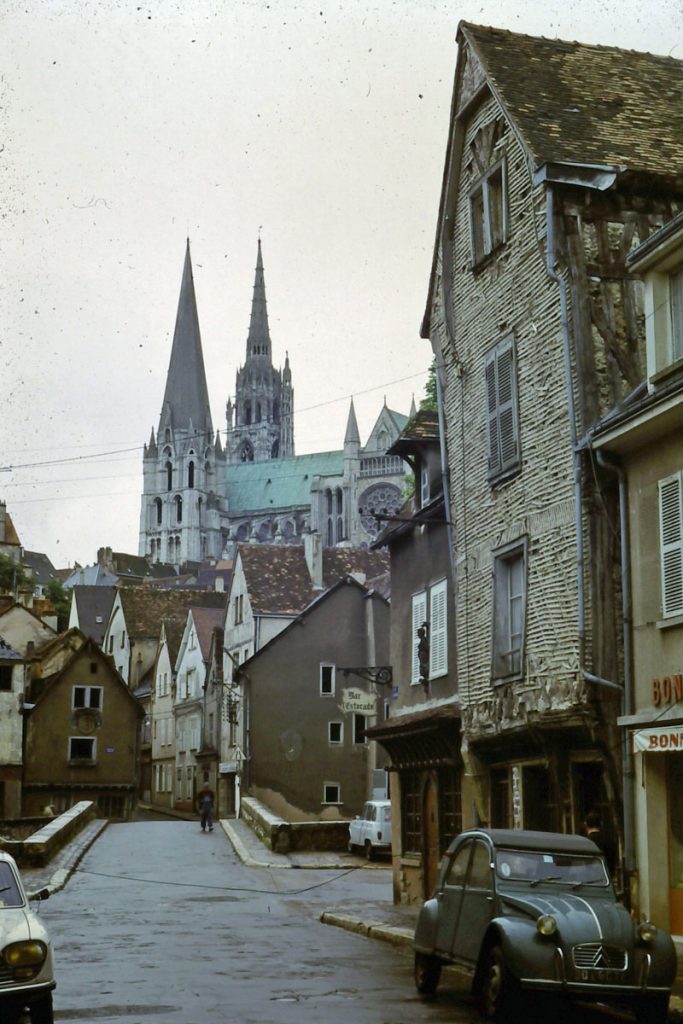
The cathedral city of Chartres demonstrates the main features of religious places of the Middle Ages. The cathedral at the centre (on the site of several previous cathedrals), was built about 1200, still dominates the skyline and is surrounded by narrow winding streets. (I took this photo in 1969)..
Similar place characteristics on a smaller scale at the village of Weobley in Herefordshire, England. The church at the centre of the village was built in the early 12th century. The timber frame buildings close to the church were built about 1500; those in the foreground are more recent, probably replacing older ones adjacent to the wide street which would have been the market place.(Photo was taken about 1970).
This was, however, also a time when kingdoms jostled for power and control of territory. Wherever there was a threat of attack by a marauding army places were built with security in mind – villages on hilltops that offered some degree of defence, towns surrounded by walls or protected by a castle. Perhaps this generated a sense of security in the thousands of small villages producing food, or perhaps technological improvements in water and wind mills were responsible, but whatever the reason there were increases in agricultural production that contributed to economic prosperity. This led to the development a trading network across much of Western Europe, especially for wool but also for tin, lead, wine and timber, and this trade generated the wealth necessary for constructing churches, and for making the places where those churches were located.
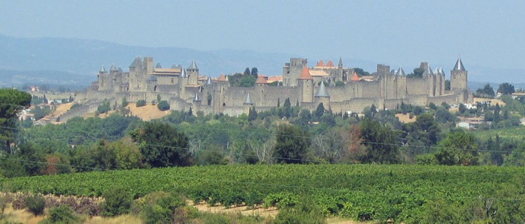
The walled medieval city of Carcassonne in southern France – much restored in the 19th century. Most of the walls and the church they protect date from the 13th century.
With economic growth came population growth, and in the 11th and 12th centuries the population of Europe doubled. Much of that growth was accommodated by rebuilding towns that had decayed during the Dark Ages or by constructing new towns. The former often had an organic maze of streets following routes of old tracks and paths; many of the new towns were roughly planned with a loose grid pattern of streets, a square or wide street for a market, and a castle wherever defence was a priority. In both cases streets would have been crowded with a variety of buildings, some substantial with workshops or stores at ground level and residences above, others little more than shacks, and all constructed of whatever materials were locally available – limestone, sandstone, timber frames filled with wattle. The result was that places, even if they were centrally planned, for instance as defensive settlements, were as diverse as the regions where they were located. This diversity has now come to be regarded as a major amenity, and many medieval places, with their picturesque combinations of church, castle, distinctive architecture, and a maze of streets most easily travelled on foot, have recently been pedestrianized and become popular tourist attractions.
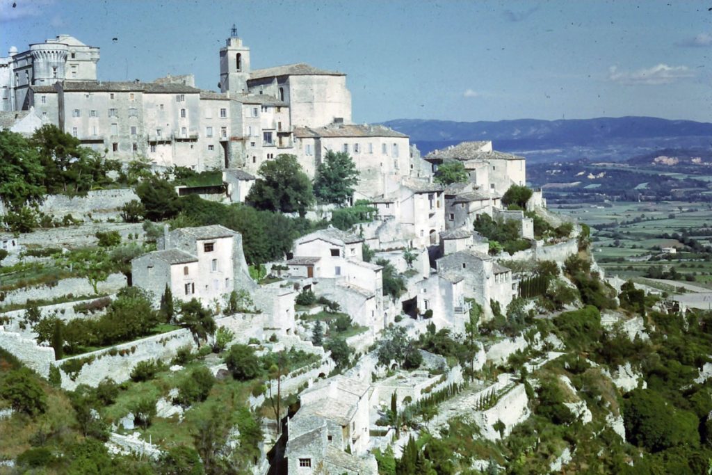
On the left the small town of Gordes in Provence, France, is an example of a medieval village on a hilltop site that provided some security from attack, with the church and a castle occupying the highest parts of the site. The buildings on the steep hillside illustrate the organic character of many medieval town plans, as do the winding, narrow streets of Arles, also in Provence, on the right.
Medieval place experiences were not entirely local. Although travel was dangerous and roads were little more than grassy, muddy tracks used by pack animals that could only be travelled on foot or horseback, clerics on official Church business and merchants on their own business regularly travelled between towns and different countries. A few million devout Christians took part in Crusades to Jerusalem, the central place of the Christian world. Many others made pilgrimages either to nearby shrines or to more distant ones such as Canterbury or Santiago de Compostela. In short, knowledge was shared throughout the places of the Christian world, including the principles for the layout of Gothic churches and abbeys, such as their orientation and the arrangements of altar, nave, choir, transept, and so on. Indeed the masons responsible for much of the construction of churches were itinerant, but they also had to adapt the standard design requirement to specific sites and to use mostly local building material because it was too difficult to move stuff around. This was done with remarkable skill, and the consequence was buildings that, although they shared the same standard elements, enhanced rather than diminished the identities of places.
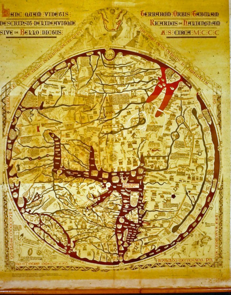
Medieval understanding of the world and its places was, like towns and villages, structured around religion. This is the Hereford Mappa Mundi, made in 1300, and the largest medieval map known to exist. Jerusalem is in the centre because it was seen as the centre of the world in Christianity, with the British Isles bottom left the Mediterranean the centre bottom, the Red Sea top right, and the circumambient ocean on the outside.
In spite of the remarkable solidity and scale of medieval churches and castles (many of which have survived to the present day), there seems to have been a sense at the time that medieval places were just stepping stones to heaven, that religion was not a whole solution to life’s problems. This became especially apparent with the plagues of the 14th century, when the Black Death spread along trade routes and caused the death of more than 30 percent of the population of Europe. Neither faith, nor churches, nor castles were able to protect people and places from epidemics (nor, it seems in the covid-19 pandemic, can science and the efforts of centralised governments, though those should mitigate the relative scale of the consequences). Many villages were abandoned because almost everyone died, and in towns as well as the countryside the resulting shortage of labour weakened the authority of the Church. This was exacerbated by the fact that the secular ideas of classical Greece and Rome had begun to infiltrate medieval thinking in Western Europe. The character of medieval places began to shift. While religion remained important and great churches and cathedrals continued to be built for several centuries, trade and manufacturing began to play increasingly important roles in politics and daily life. Self-governing guilds of professional craftsmen formed in prosperous cities, market halls were constructed, some almost as large as cathedrals, and a sense of secular community and cooperation began to develop. A new phase of placemaking was emerging.
Well-ordered Places and Uprooting in the Age of Reason “Tis all in peeces, all cohaerance gone” declared the poet John Donne at the end of the 16th century. I think he had suddenly become aware that the values of religious world in which he had grown up had lost their import. For places a new type of coherence, one based on reason rather than religion, had in fact been developing for some time. The writings of the Roman architect/engineer Vitruvius had been discovered in the mid-15th century, and since then newly made buildings and places had begun to take on a classical character. Churches in Italy, including St. Peter’s in Rome, were built with columns, pediments and domes similar to those of ancient Rome, and plans for towns, including the square in front of St. Peter’s, were given geometric regularity.
The merits of a rational approach to making places was made explicit by Rene Descartes in 1637 in Discourse on the Method, the foundational philosophical text for the Age of Reason. At the beginning of Part 2 he declares: “Old cities which, from being at first only villages, have become, in course of time, large towns, are usually ill laid out compared with the regularity of constructed towns which a professional architect has freely planned on an open plain.” He suggested that the “indiscriminate juxtaposition [of buildings]” and the “crookedness and irregularity of the streets” in old cities (i.e. those of the Middle Ages) must have been a matter of chance. However, towns planned by architects demonstrate “human will guided by reason.” He may have been thinking of entirely new towns that had to be fortified because they had a strategic role in defence and were built in elaborate geometric star patterns.
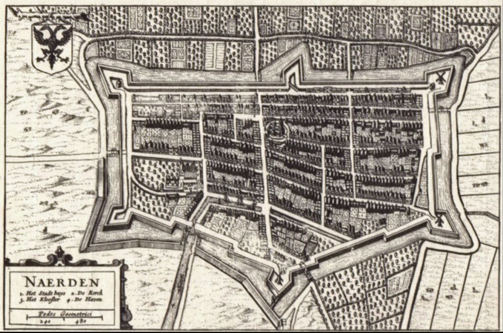
The star-fort of Naarden in the Netherlands, laid out in the 17th century was part of a ring of defensive settlements intended to protect Amsterdam. The promontories allowed cross-fire in the event of an attack. The orderly street pattern and rectangular fields outside the walls demonstrate Descartes’ ideal of planning according to “human will guided by reason.”
In fact, the shift to rational order in making places had been underway for more than a century partly because of the renaissance of classical ideas, and partly because the dissemination of these had been facilitated by the invention of the printing press in 1450. This promoted literacy, democratised education, and made it possible for new ideas to spread rapidly from place to place. Contemporary improvements in navigation ensured that some of these places were in distant colonies on recently discovered continents. Place names and cultural practices were transplanted, and, in perhaps the most notable indication of the placemaking preferences of the Age of Reason, so were the rational town plans that were coming into fashion. This was nowhere more clearly demonstrated than in Spanish Colonies. In 1513 King Ferdinand of Spain issued instructions for the expedition to the coast of Central America: “Let the city lots be regular from the start, so once they are marked out the town will appear well ordered as to the place which is left for a plaza, the site for the church, and the sequence of the streets; for in places newly established proper order can be given from the start.” These general guidelines were elaborated in minute detail in 1573 in Philip II’s Laws of the Indies for building new settlements. Their impact is still apparent in the regular townscapes of almost all the colonial settlements of Latin America.
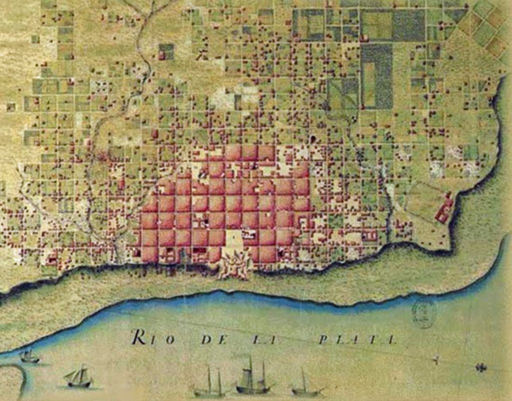
The 1580 plan for Buenos Aires – a grid of squares with a central plaza where the church and government buildings were located. This geometric approach to planning colonial places was used throughout Latin America. Source: Patricia Sendin
From about 1550, as the theocracy of the Middle Ages waned, the growing power and wealth of kings and nobles came to be displayed in great palaces and country houses which left no doubt that these, not cathedrals, were now the places where real authority resided. Their architecture was often in the classical revival styles of the Renaissance, and they were surrounded by geometrically arranged landscape gardens, incorporating sophisticated topiaty, lakes and fountains that revealed the strength of human reason in bending nature to its will.
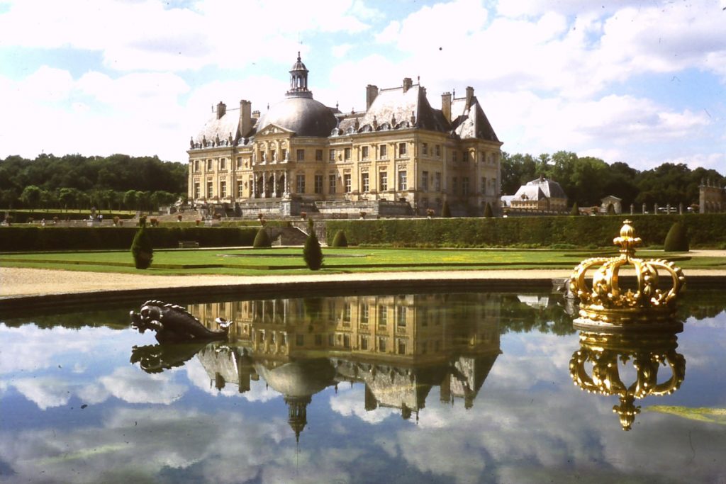
The great and wealthy places of the Age of Reason were not cathedrals but palaces surrounded by manicured landscape gardens, This is Vaux le Vicomte, built around 1660 south- east of Paris for Nicolas Fouquet, the superintendent of finances for King Louis XIV.
Wherever towns were created, such as St Petersburg in Russia, or remade, such as Lisbon after the earthquake of 1755, or added to, such as the New Town in Edinburgh in the late 18th century, they were laid out in the rational manner, guided by human reason. In the countryside the irregular strips and furrows of feudal agriculture were remade into angular fields more suited to more efficient agricultural practices. The Age of Reason imposed order on the landscape.
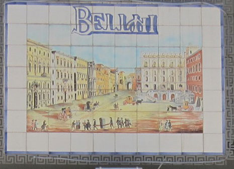
A wall plaque in Piazza Bellini in Naples with a rendering of the well-proportioned urban environment that was the ideal for making urban places of the Age of Reason – townhouses next to the street, windows in neat rows, smaller at the top, neat cornice lines, all arranged around an urban square.
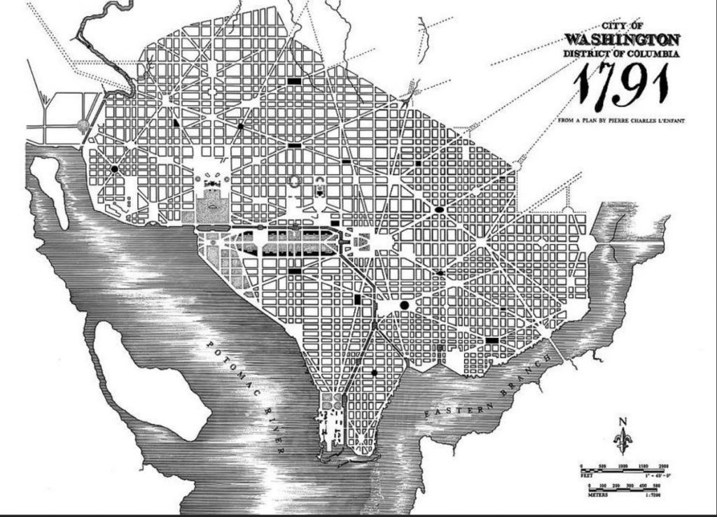
The apex of this redesign of the world came at the end of the 18th century in the newly created United States of America, where orthogonal surveys were adopted as the basis for preparing much of the new nation for settlement. Rectangular patterns were imposed on countryside and towns alike. In that same spirit, the new government commissioned a plan from the French-born American architect Pierre Charles L’Enfant for the capital city of Washington D.C., a plan that celebrated the rational principles of democratic government, with a great avenue (the Mall) leading to the Capitol, and other, slightly less grand avenues leading to the White House and cutting across much of the the rest of the city.
L’Enfant’s 1791 plan for Washington D.C., is the culmination of the ideals of town planning and placemaking in the Age of Reason, a background grid of streets, with diagonals superimposed, and the mall and grand avenues leading to the Capitol and the White House. In fact, the mall was used for railroads in the 19th century and the plan was not fully implemented until the end of the 19th century.
However, places in the Age of Reason were not all order and reason. The Enlightenment cast some dark shadows. The historian Fernand Braudel described the great capital cities of the time as “urban monstrosities… machines for creating both civilization and misery.” He was thinking of Paris, which by the mid-18th century had grown to 600,000 people, and London which had 750,000. While these both had new districts of elegant streets with circles and squares lined with well-proportioned dwellings, they also had neighbourhoods of great poverty, often where medieval bits of cities remained, and where, as William Hogarth’s contemporary engravings of Beer Street and Gin Lane show, people survived in crowded squalor and dulled their misery with wine or gin.
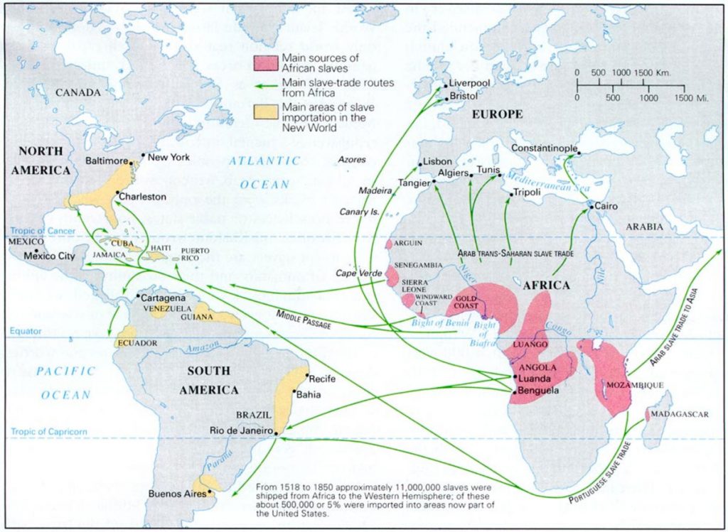
Furthermore, the Age of Reason was no exception to the fact that the creation of new places, no matter how reasonable, inevitably involves the destruction of existing places. The great palaces and country homes with their landscapes gardens often required the displacement of entire villages. On a far larger scale the massive placemaking aspects of colonialism were counterbalanced by equally huge place unmaking as indigenous peoples were pushed aside and devastated by imported diseases. Most dramatically of all, about 13 million Africans were uprooted from their homes and transplanted to other continents and unfamiliar places – 4 million to Brazil, 2.5 million to Spanish colonies, 2 million to British colonies of the West Indies and North America. The history of place is about uprooting and destruction no less than the making of places.
The great displacement of the Age of Reason. This map shows the places where slaves were uprooted, and the places to which they were taken, between 1518 and 1850. Source: Tracing African Roots https://tracingafricanroots.wordpress.com/maps/slave-trade/
Places in the IndustrialCentury The orderly practices of the Age of Reason for making places trickled on into the early 19th century in urban developments of elegant Georgian houses and in orthogonal surveys to prepare territories for settlement. However, their impetus had begun to wane before the end of the 18th century as innovations in manufacturing, such as the spinning jenny for cotton weaving and steam engines, heralded the onset of the Industrial Revolution and entirely different, utilitarian approaches to making places that prevailed until 1900 and lingered well into the 20th century.
The impact of this industrial shift outweighed all previous changes in placemaking. Indeed it effectively made all previous places appear obsolete. In 1800 at the beginning of the Industrial Century, city streets and farms still had much in common will all the places that had been made in previous ages – whether the Middle Ages or Ancient Rome and Greece – buildings were assembled by hand, on sites prepared by hand, most people still walked everywhere, houses were lit with candles, noises and smells were of animals and people. A hundred years later smells and noises were of machines which did much of the work, including making mass-produced possessions, buildings were coated in coal dust, hills were levelled with steam-shovels, people rode in streetcars or railways, streets had electric lights and were draped with telephone wires. The industrial age changed places in ways that that were utterly unprecedented.
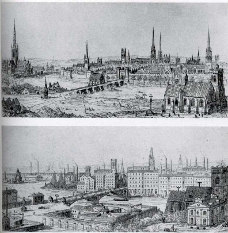
A drawing from Augustus Pugin’s book Contrasts, published in 1835, comparing ‘the noble edifices of the 14th and 15th centuries and similar buildings of the present day.‘ A skyline of churches and spires replaced by massive factories and their chimneys.
In the background of these changes was a dramatic acceleration rate of population growth, with its inevitable consequence of more people in more and larger places. The population in Europe doubled between 1800 and 1900 (numbers are not precisely known, but from about 152 million to 296 million); the population of England, the hearth of the Industrial Revolution, quadrupled, from 7.8 million to 30 million. Even though industrialisation caused serious pollution and, for some, grinding poverty, the main reason for this growth was reduced mortality – fewer children were dying and people were living longer, probably because of improved diets. It helped that a large share of the growth was accommodated by emigration to the great spaces of Australia, New Zealand, South Africa and particularly North America, where the United States grew from 5.3 million to 76.2 million between 1800 and 1900, at least 30 million of them immigrants. Many of those immigrants had come from rural regions with failing economies who had chosen to uproot themselves to seek a better life. In the new world the result was placemaking that spread across continents as settlers put down new roots. In the process, of course, indigenous populations were displaced, so this was also a time of great place unmaking.
Population growth in both the old world and the new was concentrated in towns and cities where factories provided relatively unskilled jobs paying wages which afforded a quality of life that, in spite of the pollution and slums, was often better than that of a rural labourer. In the United States in 1800 only 6 percent of the population was urban, by 1900 it was 40 percent; in England in 1800 about 33 percent was urban, in 1900 it was 77 percent. The rates of growth in individual towns and cities was dramatic. Bolton, a centre of innovation in cotton manufacturing in England, grew from 12,500 to 168,000 over the course of the century. London grew from about 1million to 5 million. Chicago grew from 5,000 in 1840 to 1.7 million in 1900. The character of urban places was remade, not least because so much of them was new and on a huge scale.
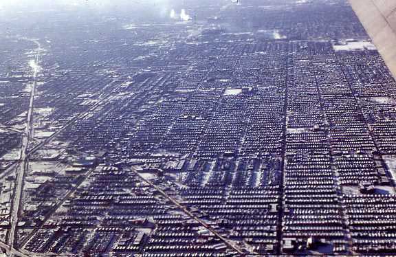
This area of Chicago that was developed at the end of the 19th century is an example of the scale and uniformity of urban expansion in the industrial age
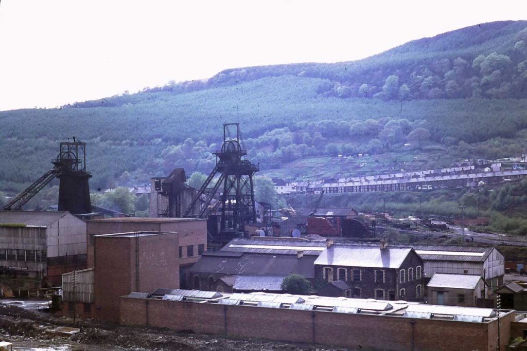
A coal mine in Treorchi in South Wales about 1975, with rows of houses for miners in the background. Except for the trees, which would have been stripped away, this place was much as it would have been a century before. However, the mines were closed about a decade after I took this photo and many signs of mining have disappeared.
Almost everything about industrial cities was unprecedented. Factories with endlessly repetitive work done in shifts were themselves new types of workplaces; huge foundries; steam driven machines; iron bridges; skyscrapers with steel frames. Tenements and row houses, more or less mass-produced to minimal standards, were new types of placeless living places. Railways provided ways of travelling at speeds hitherto considered inconceivable. And because factories and railways were voracious consumers of iron and coal or wood, the provision of these required new types of places – towns entirely devoted to a single purpose, mining towns coated in coal dust and surrounded by spoil tips, factory towns choking in smoke; a rhythm of life dictated by the demands of production and shift work. Factories, not palaces or cathedrals were the great new buildings of the industrial age, widely illustrated in engravings and birds-eye view of particular places with smoke streaming from their chimneys as symbols of progress and the power of steam. Less illustrated but scarcely less substantial were legislatures, parliament buildings and town halls, usually large and elaborate buildings prominently situated in park-like spaces. They served as a demonstration that governments of liberal democracy, whether at a municipal, regional or national level, were seats of power in the places where liberal democracy now prevailed – equal players in a capitalist world.
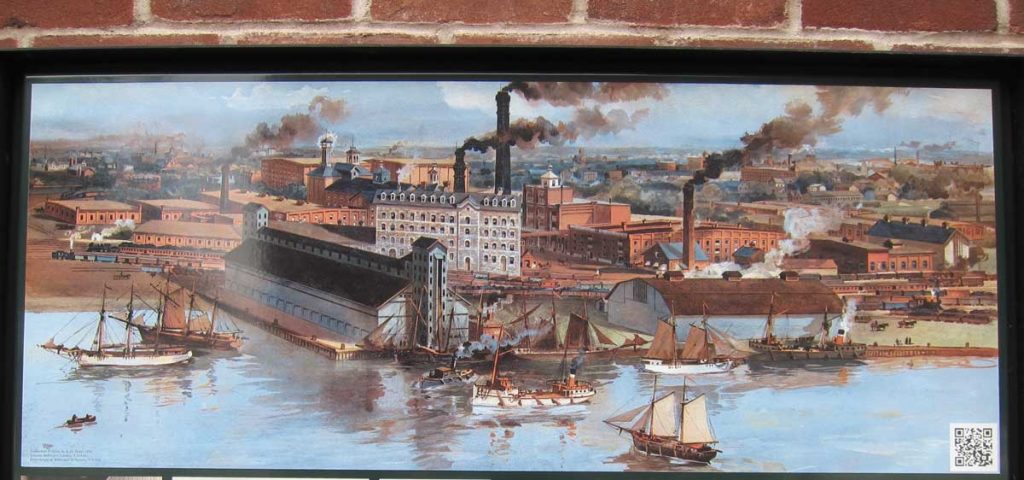
The industrial landscape on the waterfront of Toronto about 1890. A birds-eye of factories with chimneys billowing smoke that symbolised progress, and the wealth and power of industry.
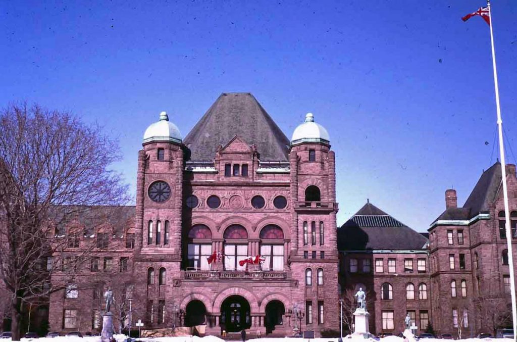
The Ontario Legislature in Toronto, constructed in the 1890s, and sited in a substantial open space in the centre of the city, is an example of the way governments in the Industrial Age demonstrated their authority by making a grand place for themselves.
In spite of these symbols of progress, in the Industrial Age cities were for the most part unpleasant, polluted, congested and uncomfortable places, especially for the poor but also for the well-to-do, because smogs, unpaved streets covered in horse manure, and epidemics of cholera and typhoid caused by unsanitary conditions, did not respect class differences. The more affluent were able to escape the worst discomforts by locating themselves on relatively pleasant hilltop locations, or moving to villas in suburban developments easily accessible by railways or streetcars. These were well-built in whatever revival style was fashionable at the time – Gothic, Italianate, Neo-Classical, Queen Anne – and many are still attractive residential districts. And over the course of the 19th century there were several major innovations that improved in the quality of places for everyone. For instance, in 1858 very hot weather in London caused unbearably foul odours to rise from the Thames, an event known as the Great Stink, and this led to improvements in urban sewerage systems (it probably helped that the Houses of Parliament are next to the river). And as urban places grew, governments ensured that they included schools, hospitals, and public parks such as Central Park in New York, and urban filtration and water distribution systems. These improvements must have contributed to the continuing rapid population and urban growth.
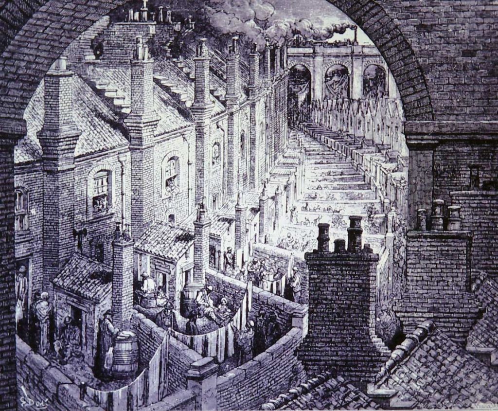
An engraving of London by Gustave Doré 1870
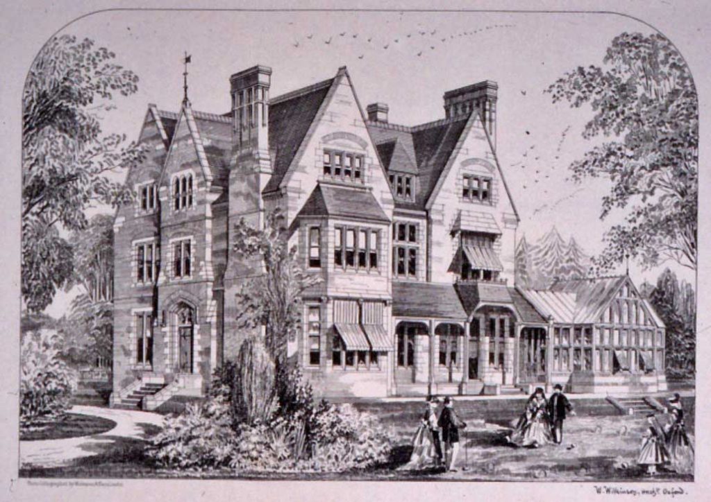
A late Victorian suburban house in Oxford
Contrasts in places where poor and rich people lived in the Industrial Period
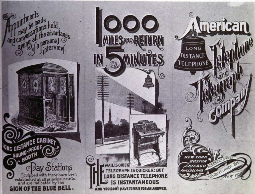
Over the course of the 19th century relationships between places underwent a radical change. Railways and the telegraph, and then electric streetcars and telephones, worked in concert to collapse time and space, the former by moving goods and people at previously inconceivable speeds, the latter by sending messages faster than messengers. What had previously been remote was made quickly accessible, locally, regionally, nationally and globally. By the 1880s suburbs were expanding rapidly along streetcar lines, Europe and India were laced with networks of railways, North America had been crossed by transcontinental railroads, and submarine cables had been laid across the Atlantic and Pacific linking Europe, Australia and America, distributing technologies, people, products, architectural fashions and practices for making places around the world. In a single century there had been a metamorphosis affecting both the identities of places and relationships between them.
This advertisement for AT&T in the 1890s captured the radical change in the relationship to distant places that had occurred in the 19th centurybecause of innovations in communications.
Places (and Placelessness) of the Modern Era During the 19th century there were many attempts to find ways to redress the social and other problems of industrialization and rapid urban growth, especially the living conditions in the places of the poor. Towards the end of the century these coalesced into socialist and reform movements that received boosts from two popular speculations about utopian places in which pollution and social injustices had been resolved: Edward Bellamy’s Looking Backward: 2000-1887, and William Morris’ New from Nowhere. These appear to have informed a remarkable proposal in 1898 by Ebenezer Howard, who had no background in politics or planning, for what he called “garden cities,” places that would offer an alternative to industrial cities.
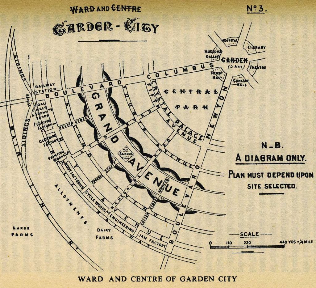
A conceptual diagram from Ebenezer Howard’s proposal for garden cities. On the outer ring are farms and allotments, then an industrial zone serviced by railways, areas for different types of housing, a ‘crystal palace’ or shopping area, and a central public park.This comprehensive way of thinking about planning places was entirely new. The geometry of this diagram was not what mattered, but the acknowledgement that all these components had to considered.
From the perspective of place what was remarkable about Howard’s proposal was that his plan was less about street patterns, which had been the focus of city planning from ancient Greece to the Age of Reason, than about creating a sort of place that would address people’s everyday needs in a way that was both economically viable and equitable. The innovative strength of his proposal attracted immediate and widespread attention, and within five years of its publication a company had been formed and land acquired to create a prototype garden city at Letchworth in England. Garden cities and new towns, following more or less along Howard’s lines, were subsequently constructed in many regions of the world. More significant is the fact that the garden city is an essential foundation of the approach to urban planning that is now used around the world, and addresses physical, social and economic aspects of how places are created and modified.
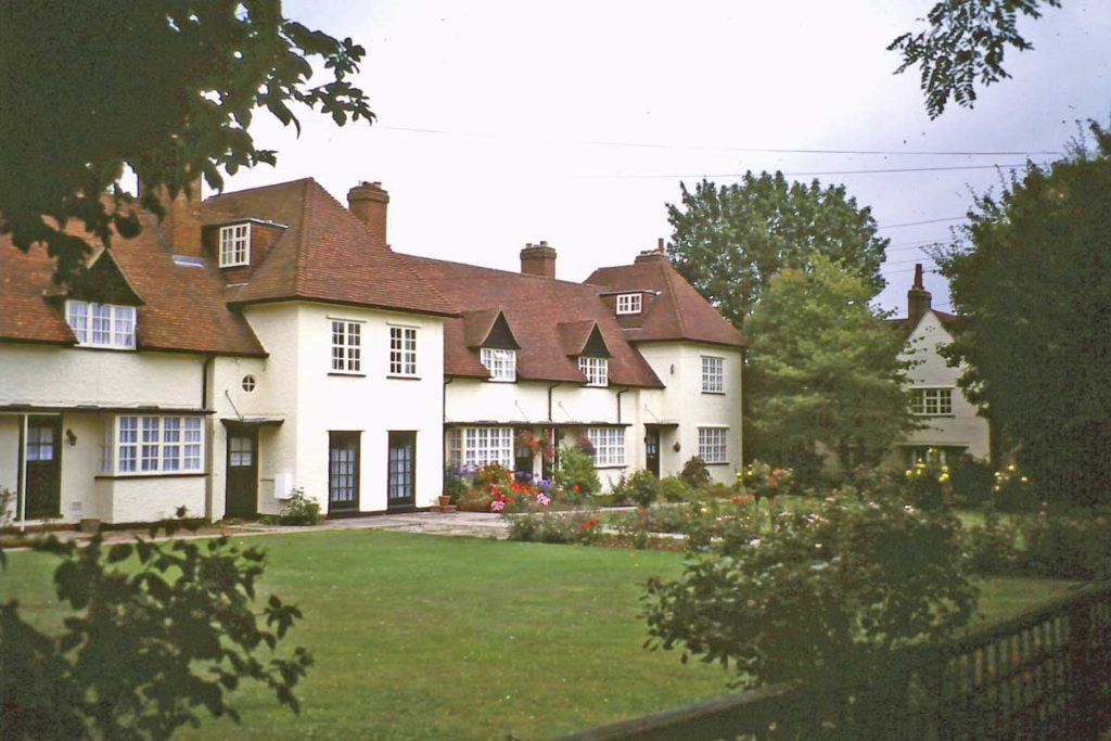
An example of the type of housing built about 1908 in the first garden city at Letchworth in England. This building was a co-operative where Ebenezer Howard chose to live – a very different place from even the wealthy suburbs of industrial cities.
Whether by chance or because of some ineffable spirit of the time, the proposal for garden cities was one of several innovations and inventions in the first decade the 20th century that have had ramifications for places. Rutherford’s ideas about nuclear physics and Einstein’s on relativity (that led to atomic weapons and the constant threat they pose for all places); the abstract art of Picasso, Braque and others (which redefined aesthetic standards); Ford’s mass-production of automobiles (which resulted in due course in automobile oriented urban development); Marconi’s wireless transmission across the Atlantic and the Wright brother’s first controlled flight (which reinforced and extended the shrinking of distance and interconnections between places that had begun with the telegraph and railways); and the conception by Adolf Loos and other European architects of a modernist, undecorated way of building that deliberately turned away from everything old and looked to the future.
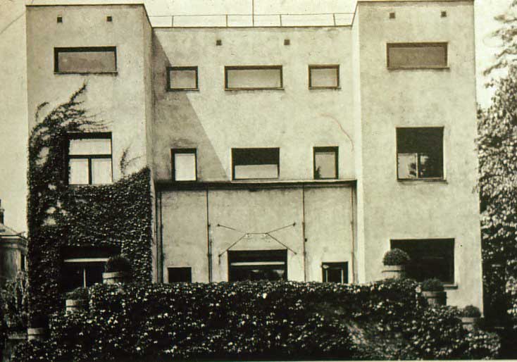
The Steiner House by architect Adolf Loos, built 1910, bore no relationship to the Queen Anne and Gothic revival houses of the 1890s, or indeed any former styles of architecture, but would not look out of place if it had been built in 2010. It rejected all revivals and decoration, use new materials, and was a prototype for modern design.
This remarkable burst of innovative thinking was interrupted by the First World War, then in the 1920s and 30s it was reinforced, for instance, by modernist designers and architects at the Bauhaus and the architect Le Corbusier. They developed modernist designs for almost everything – dishes, chairs, light fixtures, houses, apartments, (even, in Le Corbusier’s case, entire cities) that were considered efficient, progressive and ideally could be mass-produced. Their approach to architecture used modern materials of glass, steel, and concrete, took advantage of the clean energy of electricity, and had plain, unornamented surfaces. It was called the International Style, and as the name implies, it was considered equally appropriate everywhere. It was, in other words, deliberately intended to be placeless. It has been used ever since, with some refinements, for commercial, institutional and high-rise apartment buildings around the world, for airport terminals, hospitals, hotels, shopping centres and gas stations. It is placemaking that is always familiar and provides no surprises.
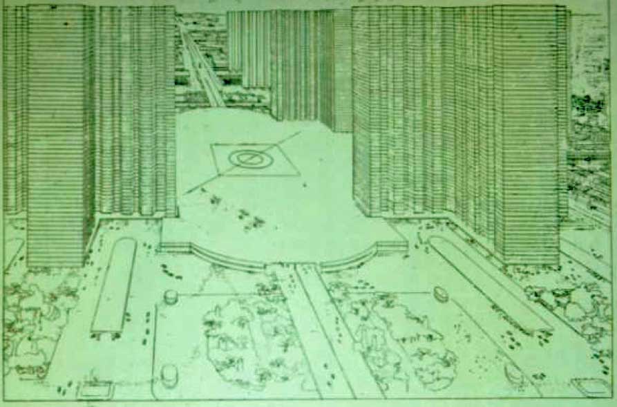
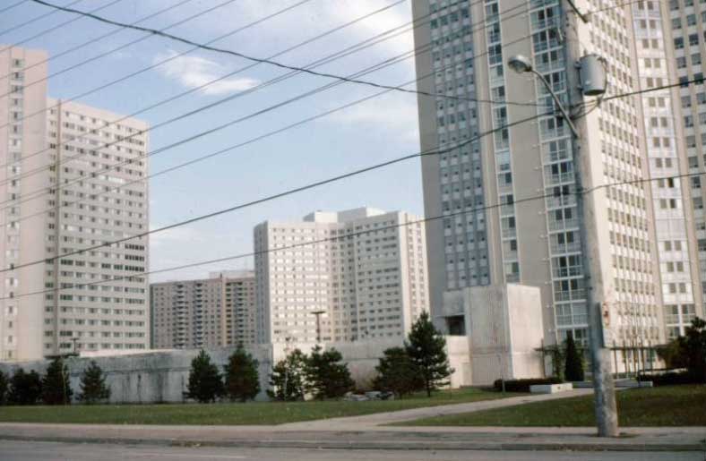
On the left, Le Corbusier’s 1930 proposal for an entirely new type of urban place, a Radiant City, of 60 storey cruciform skyscrapers that would free up the ground level for open spaces, or, in this case in the centre of the city for expressways, and (remarkably) and airport between the towers. Nothing on this scale was ever built, but Corbusier’s ideas have influenced modern places – on the right are cruciform towers of about 20 storeys, built about 1980 in Mississauga, a suburban city adjacent to Toronto in Canada.
As architects and others developed their modernist, international approaches between the two world wars, city officials found ways to adapt cities to social and technological changes. Zoning was introduced as a way of separating undesirable uses, such as abattoirs and office skyscrapers from residential areas, and quickly became a means for the segregation of most land uses – low density residential here, high density there, retail and industrial somewhere else – in effect dismantling places into component parts. To deal with rapid increases in use of motor vehicles, signs and signals were invented, different categories of roads were established with residential neighbourhoods identified as places to be protected from through traffic which would use arterial roads. Expressways were conceived (though few were built until after the Second World War. The first commercial airports were built. Billboards, neon signs, electric street-lights, gas stations, and much of the everyday paraphernalia of city streets that we take for granted, were introduced.
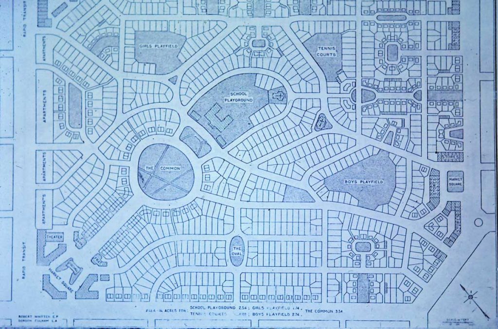
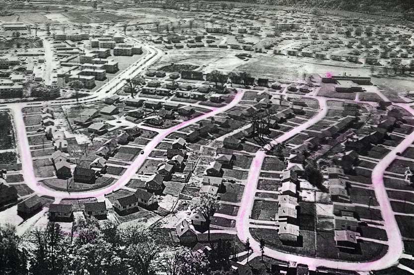
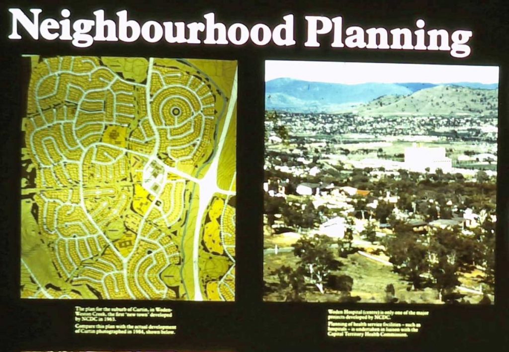
Neighbourhoods as new types of places. On the left, a diagram of a 1929 proposal for a neighbourhood unit by Clarence Perry shows a maze of curving streets and culs-de-sac for housing, with an elementary school and parks in the centre, and apartments and shops on the edges; the aim was to keep through traffic on arterial roads at the outside of the block. In the middle, curvilinear streets as part of the neighbourhood design of Don Mills, a 1950s new town development on the edge of Toronto. On the right, the idea of neighbourhood planning for suburban places explained in an exhibit in Canberra in Australia in 1985.Almost everything to do with placemaking in the 20th century was internationally shared.
The impact on places of all these innovations was quite limited because the Depression and the Second World War intervened. The war did lead to some unprecedented types of places and place experiences – vast cemeteries, concentration camps – and to deliberate campaigns of place destruction by bombing. But it was in the decades after t1945 that the approaches to placemaking developed earlier in the century were extensively adopted. And this happened in the context of a widely held view that whatever was old – buildings, street patterns, the attitudes that had led to the war – was obsolete, best removed and replaced with something modern and progressive. Modernist practices were efficient, affordable, comprehensive, made use of new technologies and available materials, and responded to new consumer trends such as automobile use.
In the 1950s war damaged parts of cities in France, Germany, Britain, the Soviet Union and Japan were rebuilt using versions of modernist approaches for making places. This was done under the aegis of comprehensive town planning, which was legally adopted in many countries (all previous planning had been advisory). Comprehensive planning considered requirements for different types of housing, schools, public parks, retailing, and traffic, was made a requirement in many countries (before the Second World War it had been mostly voluntary). In Britain it was the basis for designing new towns built from scratch on greenfield sites. In North America social housing projects of tall apartment towers designed along lines developed in the Germany in the 1920s replaced entire city blocks of old houses, while developers created automobile-oriented suburbs of boxy houses neatly arranged on mazes of curvilinear streets. Shops and services in new towns and automobile suburbs were arranged in commercial strips, drive-to plazas, enclosed shopping malls. Many stores in those places were outlets of multi-national corporations using standardized signs and selling the same products. Parking lots became a major type of land use. Zoning ensured that different types of land uses were separated. Arterial roads and networks of expressways continued the process that had been started by railways of redefining relationships between places by making everywhere accessible by car.
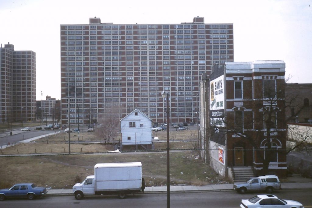
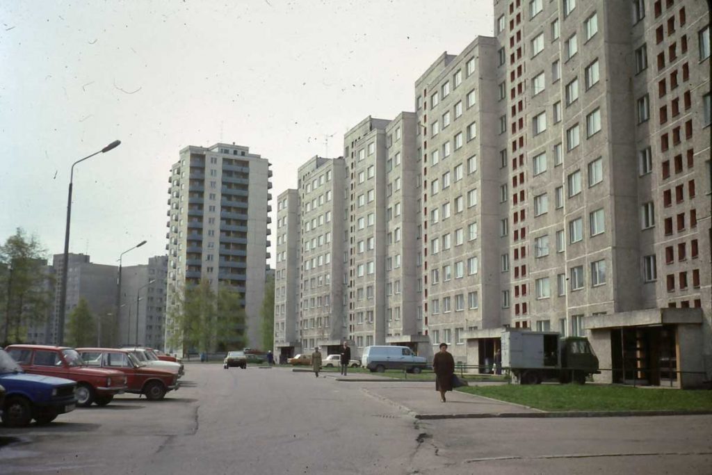
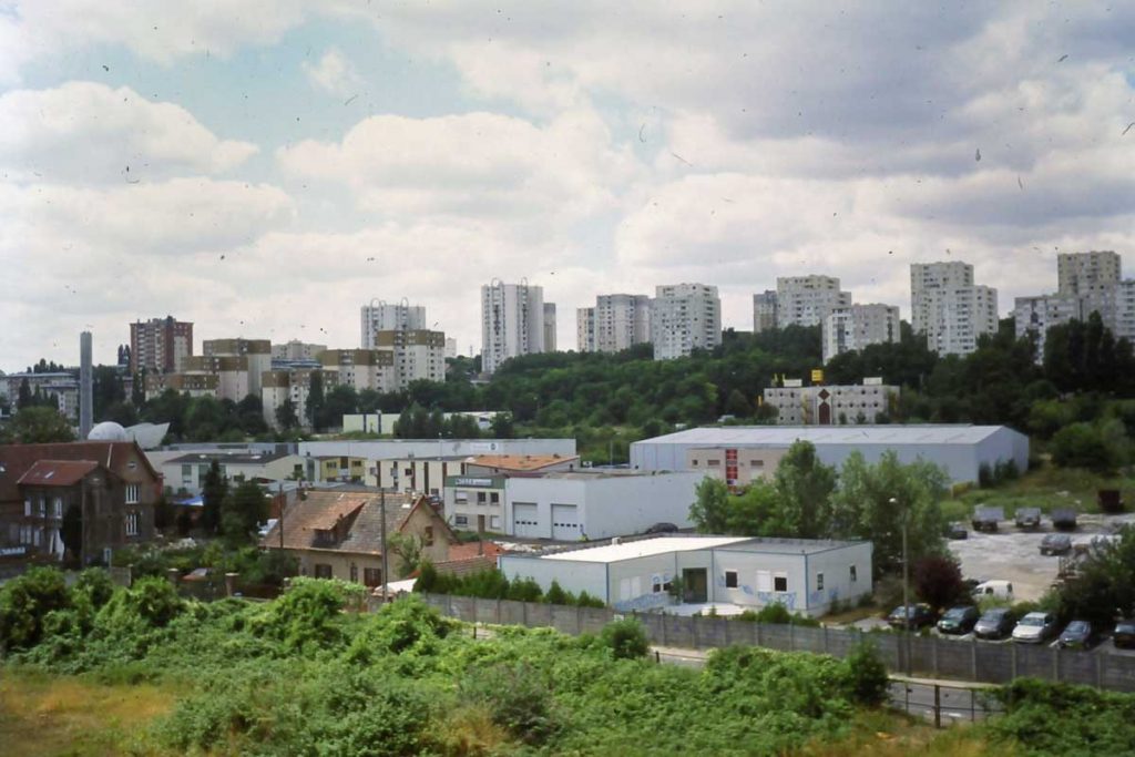
On the left, Cabrini Green in Chicago in the 1990s, showing the apartment slabs built in the 1950s as part of an urban renewal project to replace the sorts of houses and commercial blocks shown in the foreground. The slabs have now been demolished. In the centre, Soviet style apartments from the same period in Tallinn in Estonia. On the right, suburban Paris in 2005. High rise apartments were a new type of accommodation that was internationally popular in the 1950s, 60s and 70s, both as a way to replace old or war-damaged parts of cities, and to provide social housing.While all these projects were in some limited sense places, each with its own name and location, they ignored local environments and culture and were similar in form wherever they were constructed, so they were also manifestations of placelessness.i
This functional, modernist approach to making modern places can be understood as a response to the need after the Second World War both to rebuild and to accommodate very rapid population growth, almost all of it in urban areas. Between 1950 and 1970 world population grew by about 1 billion; Europe by 100 million (the equivalent of a city with a million people every two years) and the US by 50 million. Modernist placemaking provided ways to do this while improving living conditions and meeting people’s expectations for a better quality of life. It was used, with minor variations, almost everywhere – in Britain, France, the United States, Australia, Japan, the Soviet Union. The same sorts of apartment towers in the same sorts of clusters, the same classifications of roads according to projected traffic flows, the same gas stations, similar curvilinear street mazes in residential suburbs. In order to do this local traditions and ecosystems, old buildings and settlements, were treated as impediments to progress and growth. They were built over or demolished..
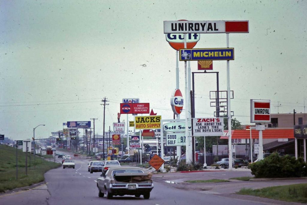
Commercial strips and the ordinary international modernism of the 1960s and 1970s was inherently placeless – similar designs, the same activities, the same multi-national corporations in urban places almost everywhere.
Of course, in some superficial sense each new town, housing project, suburb and modernist apartment tower was a place, a unique location, often with a name invented by planners or developers, somewhere people worked, lived and made their home. Nevertheless, the overwhelming effect of the landscapes created between 1945 and 1970 was one of diminished distinctiveness, of similar places offering similar possibilities for experiences, of no surprises, of placelessness.
A Summary of the Historical Periods of Places • Ancient Greek places blended spiritual, aesthetic and intellectual qualities. Public places – temples and the agora – were for expressions of shared communal identity. • Roman places demonstrated pragmatism and control that were part of an Empire with a consistent identity everywhere; spiritual life was largely domesticated, and public spaces were primarily for spectacles or displays of authority. • Medieval places had an original character because previous history had been forgotten; their the focus was religion, both literally and symbolically, though there was parallel attention to trade and security. • Places in the Age of Reason borrowed from Classical traditions to promote rational, geometric order, in part in buildings and estates that expressed the power of the aristocracy, in part by imposing rectangularity on landscapes and street plans, and in part by colonising and uprooting cultures which did not shared rationalist convictions. • Industrial places reflected the utilitarian demands of growth, capitalism and unprecedented consequences of innovative technologies, including urban expansion, pollution and the collapse of distance as a barrier between locations. • Modernity reinforced the collapse of distance, rejected the past, celebrated progress toward the future, and promoted standardization that encouraged uniformity at the expense of the identities of places.
A Shift to Different Approaches to Placemaking since About 1970 There has been a shift away from the placelessness of modernity since about 1970. Although modernist practices continue to be used they have been increasingly challenged by a widely shared recognition of the need to respect ecological processes and cultural heritage. At the same time many remnants of the industrial age – coal mines, old factories, railway lines – have been closed, dismantled or converted to other uses. There has been an enormous rise in global trade and international tourism, electronic communication has become part of everyday life, the world’s population has doubled, climate change has been identified and its consequences have intensified, migrations patterns have shifted, the deepest levels of poverty have decreased but inequality has increased.
I have reviewed these recent trends in three previous posts (Reinforcing Distinctiveness, Experiences, Theoretical Speculations). In the next post I will summarise them as part of a consideration of the implications of continuity and change for figuring how places might be made, redeveloped and managed over the course of the next few decades.
This post is the second in a series about the past and future of places. The previous one explained my overall aims and approach, and noted that my emphasis is on material places rather than the more abstract notion of place.
This is also the first of two specifically about the history of places that examine changes in the ways people have made and related to particular places since the first permanent human settlements were made about 12,000 years ago. I have divided this history into two parts mainly because I think it makes what would otherwise be a very long post much more manageable. I have take the year 1000 as a mid-point partly for convenience, but also also because evidence of how places were made and experienced before then is mostly in the form of ruins and archaeological sites, and since about then there are whole buildings, landscapes and parts of towns that are more or less intact and have been continuously used. A second post on the history of places considers, the Middle Ages, the Age of Reason, the Industrial Period and the Modern Era.
My hope is that this broad historical survey gives some indication of how places have changed over the course of human history, and will clarify whether we are currently going through another place shift, and, if so, how this might play out.
Approach and Initial Qualifications Approach: I summarized my approach, which borrows the ideas of the historian Fernand Braudel, in a previous post. To that I will simply add here that here my aim is to identify historical periods which demonstrate consistency in the ways places were made and experienced. Evidence of placemaking practices can be seen in the street patterns, heritage buildings and archaeological traces of places that still exist [incidentally, the first widespread use of the term ‘placemaking’ seems to have been by archaeologists in the 1970s]. Experiences of and relationships to places, which are more difficult to ascertain retroactively, I will consider mostly in terms of advances in communication – roads, printing, railways and so on.
The periods I identify are mostly familiar ones, corresponding for instance to those in Lewis Mumford’s The City in History, and other historical studies. I illustrate them where possible with my own knowledge of particular places, especially in Europe and North America. The histories of places in Asia, Africa, and Latin America follow different paths, although advances in communications, colonialism and global trade since about 1500 have ensured that large swathes of recent place history have been shared across continents and cultures.
Some initial qualifications (actually determined by writing a couple of drafts of the history): • Periods of places do not have precise start and end dates. Innovative practices and attitudes to place evolved over decades or centuries, came to prevail for a length of time, then were gradually replaced. • The periods are generalisations about ways of making and relating to places that reflect a particular conjuncture of social and technological practices. In effect, they identify a distinctive and widely shared sense of place which reflected the spirit of the times. • In each period there was a variety of different types of places, some wealthy, some poor, some the centres of trade and power, some remote and culturally resistant. In this brief history I am mostly interested in innovative practices that were widely shared, and I pay little attention to these non-conforming places. • Many non-conforming places were ones inherited from previous eras. Sometimes these were little more than traces in ruins and names, sometimes they were almost complete landscapes that endured because there was no good reason to replace them, sometimes they have been manifest in revivals of values and architectural styles. These remnants indicate the importance of continuity in places, which I will examine in a separate post. • Because the complete landscapes of places at any given time have always included a legacy of places from earlier periods, over the course of history this legacy has become both increasingly deep and more extensive. In other words, the current era has the greatest legacy of past places.
• And, very important, population growth and urban growth are two long-term, almost longue durée trends that underly the entire history of places. I will begin with those.
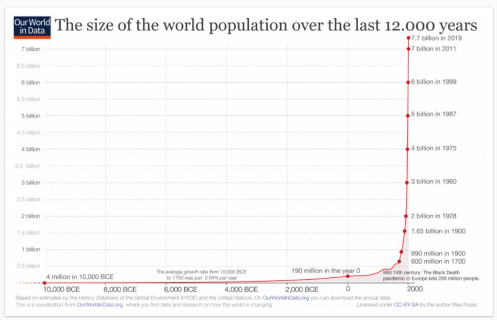
Population Growth and Urban Growth Population Growth: Almost every century in the last 12,000 years has seen more people in more parts of the world, and since about 1800 there have been many more people in much more populous places. Graphs of population growth have two distinct elements. A gentle upward incline, almost horizontal, from about 10,000 BCE, when the world population is thought to have been about 4 million, to 1800 when it reached about 1 billion. And since 1800 an almost vertical line to 2020 and the present population of about 7.7 billion. There have been regional and temporary setbacks because of plagues, famines and wars, but these scarcely show. The fundamental fact is that the history of places is a history of accommodating population growth.
World population growth 10,000 BCE to the present. Source: https://ourworldindata.org/world-population-growth
Urban growth. Population growth has been accommodated through diffusion – more people in more places – and in some ways from the outset but especially over the last two hundred years, by concentrating populations in urban places. The first cities (by current standards, actually small urban settlements with populations of a few thousand) were founded about 3500 BCE. Since then the tendency of cities everywhere has been to grow bigger. This is important to the history of place for two different reasons. One is that the proportion of people living in cities has steadily increased, though it probably remained under 10 percent in most parts of the world until about 1800. Since then it has accelerated faster than population growth, and now surpasses 50 percent for the world and 80 percent in most developed countries.
The second reason is that the history of cities is better documented in archaeological and written records than the history of rural areas. This means that there is a bias towards urban places, even when they held only a small proportion of the population, simply because there is more information about them.
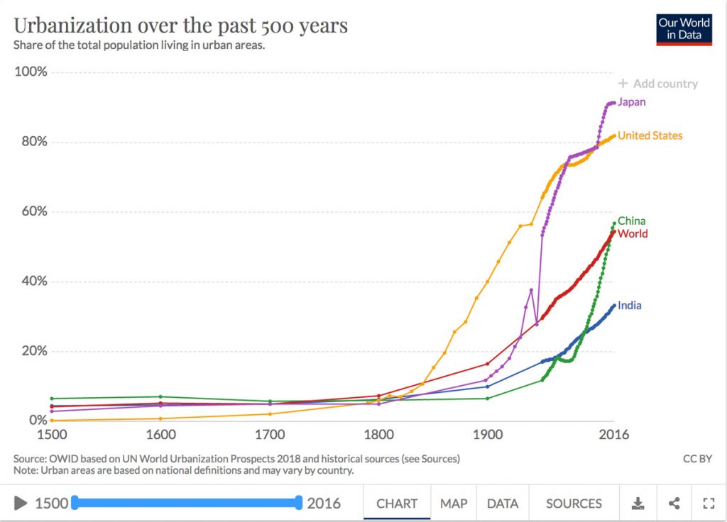
Urban Growth since 1500 in the world (the red line) and various countries. Source: Our World in Data. https://ourworldindata.org/urbanization
The First Stable Places Humans in the Stone Age depended on foraging and hunting, were continually on the move, and left little evidence of life in fixed places, presumably because they did not have the skills, means or inclination to modify environments. Nevertheless, they must have had the sense of place shared by all sentient beings that made it possible to find their way around, and to get back to wherever there was good shelter or food. In addition, cave paintings in Indonesia and Spain, dated respectively to 44,000 BCE and 35,000 BCE, indicate that they identified places with special significance.
Places as distinctive and enduring creations where people lived and died, and through which they connected to the world around them, begins with sites of stone monoliths, such as the one at Gobleki Tepe in Turkey made about 9,000 BCE. That, and other places with standing stones made over the course of several millennia (including Stonehenge about 3000 BCE), seem to have been associated with burial and/or ceremonial sites. Given the considerable work necessary to create those, and the fact that they were roughly contemporary with the gradual domestication of crops and animals, it is reasonable to assume that these were associated with settlements that provided a measure of security and made possible long-term connections between communities and particular locations. In other words, though there is scant archaeological evidence of domestic placemaking, it was probably then that enduring attachments to place first developed.
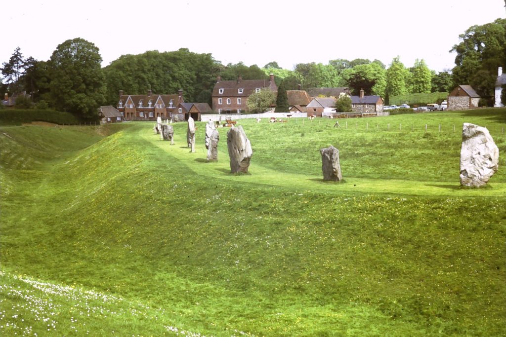
Earthworks and standing stones at Avebury in England are remnants of a ceremonial site dating from about 3000 BCE. The site is partially occupied by a village with medieval origins.
The Invention of Urban Places A placemaking leap from small settlements and ceremonial sites to cities happened about 3,500 BCE in several locations around the world, most notably in the valleys of the Tigris and Euphrates in Mesopotamia. These ancient cities were distinctively different from all previous settlements because of their relatively large and dense populations, planned streets laid out in a grid pattern, tall buildings, marketplaces, and grand temples. They were also centres of administration where writing on stone tablets was invented, perhaps to keep records of food supplies, and this presumably resulted in a class distinction between the literate few and everybody else. Although the great majority of people continued to live in small villages for the next three millennia, these early cities were a place invention that endured, steadily grew, and now prevails.
The first city in Mesopotamia is thought to have been Uruk, not far from what is now Baghdad. At its peak about 2,000 BCE it may have had a population of 50,000 but eventually declined for various environmental and political reasons, and was abandoned before 300 CE. What is often considered the first work of literature, The Epic of Gilgamesh, was written there about 1800 BCE in cuneiform on stone tablets. It begins with what probably the first written description of a place:
“The massive wall of Uruk, which no city on earth can equal. See how its ramparts gleam like copper in the sun. Climb the stone staircase, more ancient than the mind can imagine, approach the Eanna Temple, sacred to Ishtar, a temple that no king has equaled in size or beauty, walk on the wall of Uruk, follow its course around the city, inspect its mighty foundations, examine its brickwork, how masterfully it is built, observe the land it encloses: the palm trees, the gardens, the orchards, the glorious palaces and temples, the shops and marketplaces, the houses, the public squares.”
The Epic of Gilgamesh, Stephen Mitchell translation, 2004
Greek City-States and Knowledge of Other Places The practice of building urban places slowly spread from Mesopotamia east to India and westwards to the Mediterranean. In Ancient Greece in the first millennium BCE the practice began to take on a distinctive character that is notable in part because such good archaeological and written records have survived. An important part of this distinctiveness was the development of city-states, essentially politically defined urban regions, each with a city supported by an agricultural economy, and with its own deity revered and honoured in temples such as those on the Acropolis for Athena, the goddess of Athens. Each city-state also had its own form of government to direct the everyday life of its citizens. The most notable was the democratic system invented in Athens, which redefined how at least some people related to place because citizens (which meant adult males, not women or slaves) could meet in a public space, the Agora, to debate and vote on matters that would affect life in the places where they lived.
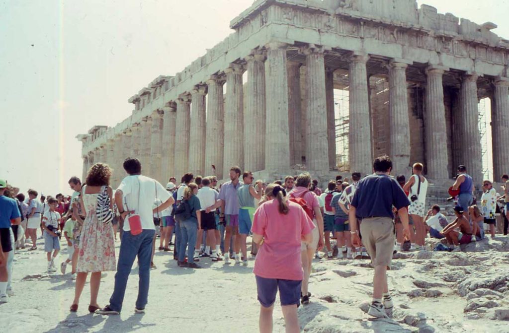
The Parthenon in Athens. The aesthetically meticulous architecture of Greek temples set a standard for western architecture that has been repeatedly revivedand isstilladmired. In this respect, ancient Greek placemaking has echoed through the centuries
Some Greek cities, such as Athens, had inherited irregular or organic plans from earlier settlements, but where possible considerable attention was paid to creating a carefully arranged layout of spaces such as the Agora and sites of temples. In cities that had to be rebuilt (for instance after a war) these public spaces were incorporated into a layout system of rectangular city blocks in what can be considered the first systematic instances of placemaking and town planning,
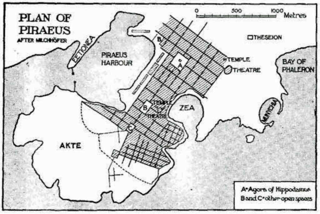
The plan for Piraeus, the port of Athens, about 450 BCE, by Hippodamus (considered to be the first town planner), showing rectangular blocks, with spaces for the Agora, and Temple and Theatre.
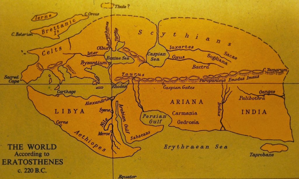
In Hellenic Greece people were often identified by their birthplace – Hippodamus of Miletus, Eratosthenes of Cyrene, and so on, and the intellectual culture included a desire to understand the world and its places. Eratosthenes, the person who is attributed with the invention of the word ‘geography,’ was for some years around 225 BCE the librarian at Alexandria, and his books, though all lost, are known to have included both a map and a set of descriptions of known countries. While Ancient Greece did not have an empire, its citizens explored and migrated to various places in their known world, in effect creating what in retrospect appears to have been a geographically open and extended sense of place.
The known world according to the geographer Eratosthenes about 220 BCE, indicating the extended sense of place in Ancient Greece. The lines indicate suggest the way he accurately measured the circumference of the earth by measuring the angles of shadows in wells along the line of longitude
Standardized Places of the Roman Empire About 150 BCE the city-states of Ancient Greece were assimilated into the expanding empire of the Romans, who then borrowed and adapted many aspects of Greek thought and placemaking, including architectural styles and aspects of town planning. But whereas the Greek attitude to place tended to be cerebral, democratic, spiritual and aesthetic, the Roman attitude was mostly administrative and practical. The Romans added innovations such as aqueducts, communal baths, and tenement buildings; amphitheatres for mass entertainment were substituted for theatres; monuments were built to honour emperors; religion was domesticated (every dwelling had its gods).
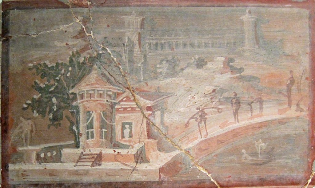
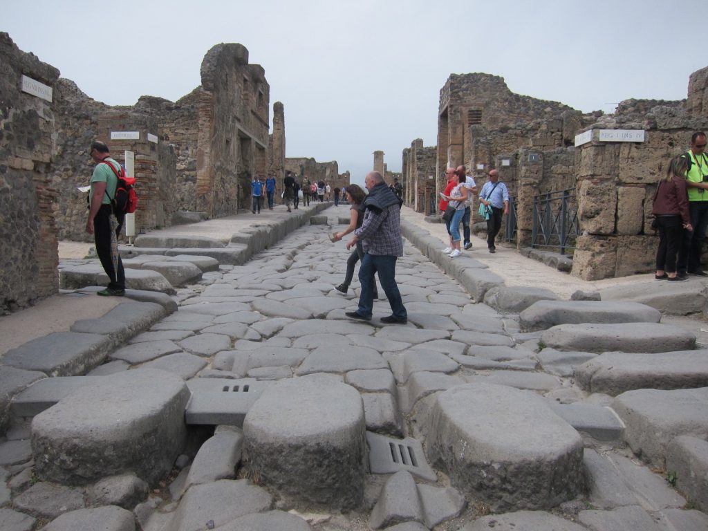
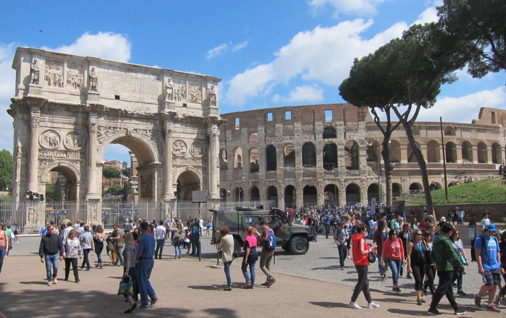
Roman placemaking. On the left, a domestic scene in a mural from Pompeii (now in National Archaeological Museum, Naples). In the centre, a commercial street with a stepping-stone crosswalk that allowed wheeled carts to pass. On the right, the Arch of Constantine (built to celebrate his military victories) and the Colosseum in Rome.
Perhaps most notably in terms of impacts on place, the Romans developed a continent wide network of roads that facilitated both communications by messages written on papyrus and rapid deployment of troops. This network allowed the imperial centre of Rome to command an empire that came to include territory all around the Mediterranean, far into the Middle East and into Britain. Wherever those roads and trade routes led, new settlements were created along lines specified in the first century BCE by the architect Vitruvius, whose books precisely detailed site selection, grid street patterns, street widths and orientation, the location and character of colonnades, and the size of city blocks. The roads and settlements offered both security and comfort to local peoples and their places, who where assimilated into the Roman way of life.
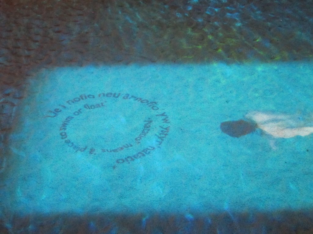
Roman culture at the very edge of the empire. This is a reconstruction of a Roman bath in Caerleon, a frontier town and military camp in Wales (that also had a small amphitheatre). The swimmer and text are projections onto the pool. The inner circle says: ‘Natatio means a place to swim or float’ (and is repeated in Welsh on the outside).
The Roman attitude to place was described by the geographer Strabo about 10 CE. “A knowledge of places,” he wrote at the beginning of his Geography (section 1.2.12), “is conducive of virtue,” and and by virtue he meant living in harmony with nature. Geographers, with their knowledge of the cosmos, wide travel, and careful observations, were especially capable of evaluating places, and this enabled them to interpret the providential order of landscapes, to distinguish good sites from unpropitious ones, and to advise others, especially political and military leaders, on how to take advantage of them. Whether the leaders paid much attention to this advice is not clear, but there is ample evidence that the great Roman network of roads and trade routes carried fashions for amphitheatres, therapeutic baths, villas with under-floor heating and elegant mosaics, and carefully organised grid town plans throughout the empire. This could be considered an early form of placelessness, though Strabo’s remarks suggest that it did involve adaptations to the particularities of places.
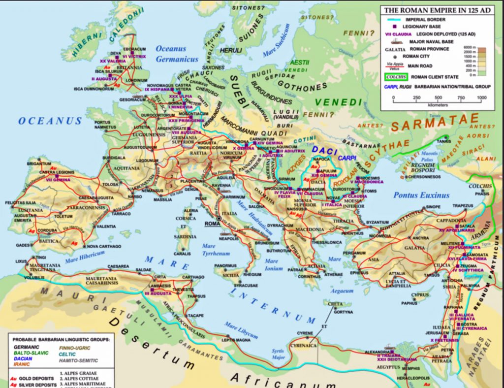
The network of Roman roads and the extent of the Empire at about its peak in 125 CE, carrying Roman culture to the frontiers, and wealth, goods and people back to Rome.
Roads and trade routes do, however, run in two directions. As they took Roman culture to the frontiers, they also brought people from throughout the empire to Rome. At its peak the city had a population of about 1 million (perhaps 30 percent of whom were slaves). It had many of the elements we still identify with large cities – stadiums, centres of government, multi-story tenements, water supply and sewerage systems. But it was also filled with noise, congestion, inequalities and what Lewis Mumford ( The City in History, p.237) describes evocatively as “megalopolitan elephantiasis.”
The Dark Ages and the Disaggregation of Places After about 200 CE the Roman empire began to decline for reasons that included corrupt emperors, widespread decadence, internal power struggles, overdependence on slave labour, administrative inefficiency, and a series of assaults by Saxons, Vandals and Goths that pushed back the frontiers and eventually reached Rome in 476 when the capital of the empire was moved to Constantinople. What happened to places during and after this decline is open to debate because between about 300 CE and 1000 CE there are few descriptions and little evidence of how people lived.
One view is that the decline of imperial control opened the way for decentralization and this led to an period of local independence and creativity. A more conventional view is that literacy and learning plummeted as government and administration collapsed, and that populations declined dramatically because of violence, starvation and disease (a devastating plague in 540 may have wiped out 1/3rd of Europe’s population, a sobering thought in 2020 as an epidemic of novel coronavirus spreads around the world and appears to be particularly acute in Europe). By the end of the 5th century the population of Rome had dropped to about 30,000, and people lived in the ruins of civilization. Elsewhere places were disaggregated, the infrastructure built by the Romans crumbled, towns and villages were abandoned or became barely self-sustaining, and the countryside was taken over by waves of immigrant invaders – Goths, Huns, Saxons or Vikings, depending on the specific region of Europe.
Those new immigrants left remarkably little evidence of placemaking and except for legacy of place names, which have filtered through into the names of towns and cities. In Britain, for instance, the suffix –borough is derived from the Anglo-Saxon –burh (e.g. Middlesborough) meaning fortified settlement, while –ham (Birmingham) and –by (Grimsby) both mean village, York probably comes from the Viking Jorvik. Normandy means the land of the North Men, or Vikings. Otherwise, the primary impact of the Dark Ages was one of taking places apart or allowing them to decay, of placeunmaking rather than placemaking.
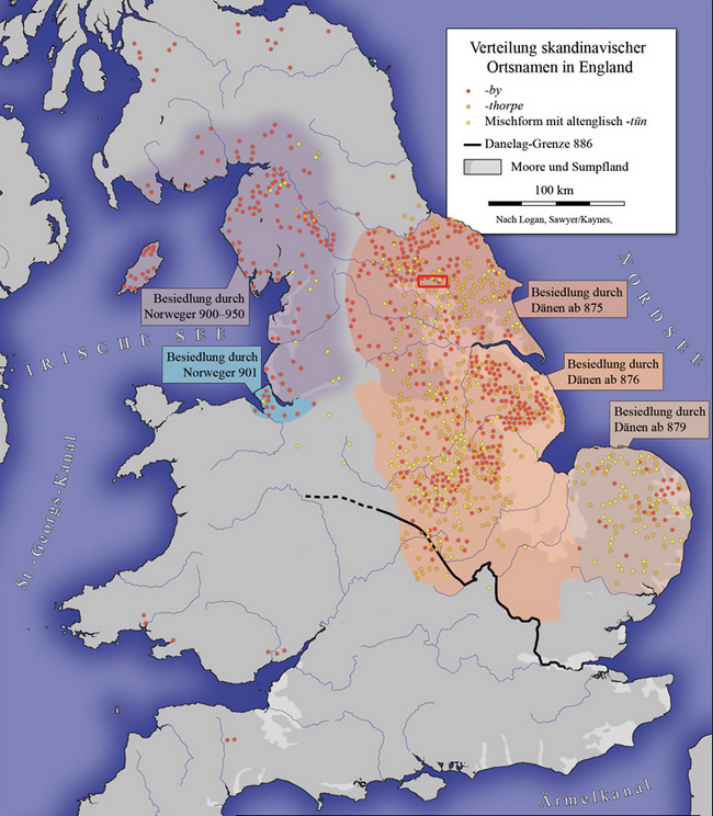
Saxon (Danien) and Viking (Norwegen) place names in Britain that identify places settled during the Dark Agesby immigrants from Denmark and Norway
The History of Places continues in another post…. Places in the Middle Ages or Medieval Period that (about 1000 to 1500), the Age of Reason (about 1500 to 1800), the Industrial Period (about 1800 to 1900), and the Modern Era (about 1900 to 1970) is summarised in the post The History of Places Part Two: 1000 to the present